Orienteering Games for Kids: Easter Challenge
I love Easter egg hunts! But I don’t love plastic Easter eggs. Last year, I promised my kids I would create our own Easter egg hunt because our town canceled theirs.
Saturday night found me struggling to fill myriads of tiny plastic eggs. After squeezing and wiggling, I finally opened an Easter egg and inserted as many jellybeans as I could — three. Then I delicately aligned the plastic lids. I gently compressed them so they would fit together.

Just I as thought I had succeeded, the egg sprang apart, showering me with jellybean confetti. Next year, I vowed, our Easter egg hunt will be different. Instead of a traditional egg hunt, I created an Easter-themed orienteering course.
What is Orienteering?
Orienteering is a sport where participants navigate from point to point using only a map and a compass. The goal is to complete the course in as little time as possible. While most courses are designed to be hiked or run, some orienteering events are completed on mountain bikes or skis.
A similar activity, geo-caching, uses a GPS device to seek a cache or container filled with interesting objects. Both activities rely on map-reading skills and encourage outdoor exploration.
Why Teach Orienteering?
Orienteering is fun!
Most orienteering events occur in the woods and participates can enjoy exploring wild spaces. Unlike a traditional hike, orienteering stimulates both the mind and body.
It’s provides a unique challenge
As if they were solving a puzzle, participants must quickly determine the best path to reach their goal and circumnavigate obstacles blocking their way. Speed is also important. Many orienteering competitors run between checkpoints to achieve a faster time.
Orienteering teaches important outdoor skills
Orienteering teaches participants to read maps and become more self-reliant. How many times have I panicked when my phone cannot connect to the GPS? (Answer: Too many times.)
By learning orienteering with my kids, I might be able to break my dependence on Google Maps and hopefully develop a better sense of direction.

Orienteering skills are essential to hiking. Many hikers mistakenly rely on their cellphones and trail markers to guide them. Cellphones are unreliable trail maps.
Mountainous and remote areas are known for their sublime beauty … and their poor cell service. Furthermore, cell batteries fail, especially in cold conditions.
According to the National Park Service, one of the leading reasons people needed rescue was errors in judgment or lack of information about the trail. If you know how to read a map and compass, you are less likely to become lost, misjudge the trail, and need assistance.
How to Create Your Own Orienteering Course for Kids
A Few Days Before Easter
This activity requires a little upfront planning, but it promises to be educational and exciting (or should I say egg-citing). I recommend deciding where to hide the baskets and creating a map at least a few days in advance. Setting up the course takes a little more thought, but in my opinion, it’s much less tedious than filling Easter eggs.
Create a map
Before selecting our checkpoints, I saved a private map of my yard using Google’s Maps. Under “Your Places” Google allows users to save maps of an area. I titled my map “Easter Basket Hunt.”
Plan your course
Once the map was created, I went outside to plot my course. The quarter-mile long orienteering course I created has three checkpoints and a final treasure trove. My kids will be required to find each checkpoint before they can find their baskets.
Google Maps allows users to save locations by dropping a pin on that location. To drop a pin, open Google Maps, press and hold on your current location. A pin will appear. After you create the pin, label it (more detailed instructions here.)
I dropped a pin at the starting location, my house. Then I walked deeper into my backyard. When I found an interesting hiding spot, I used my phone to drop pin at my location. I set checkpoints at the dilapidated stone wall, a gnarly rock outcropping, and the swamp where the frogs spawn.

Print the map
After my pins were set, I exported the map as a KML file. The file may be saved to Google Docs or to Google Earth. On Google Earth, the map may be edited further or saved as a PDF. Just before Easter, I’ll print a map for each kid.
Easter Morning
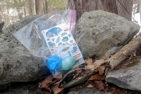
It’s time to hide those baskets! Because I don’t want to leave them out overnight for the neighboring raccoons, I’ll set up the course in Sunday morning. Using the map on my phone, I will place three re-closable bags with stickers and Easter eggs at each of the checkpoints and hide my kids’ baskets at the final location.
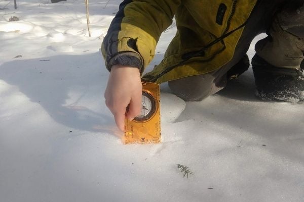
Before we begin, I plan to give my kids compasses, maps, and some brown paper bags. The compasses are an Easter gift, and I will need to teach my kids to use them. I’ll remind them to align the red needle with the red line marked north. Then we will practice identifying east, west, north, south.
Learning to Count Paces
A map is only useful if you are able to convert distances on the map to distances on the ground. This is frequently done with pacing, which estimates distances in strides. Although not always very accurate, it is very convenient. After all, your feet are always with you.
A pace measures the distance from one foot leaving the ground to when it contacts the earth again. If the child starts walking with his left foot on the ground and his right foot in the air, he will count one only after the left foot touches the earth again.
To help my five-year-old count correctly, I will encourage him to say “And a half!” when the right foot lands. He might sound a little funny saying, “Half – one – half — two …” but his pace count will be more accurate.
Since it’s Easter and not a school field trip, I’ll use a few (only a few!) plastic eggs filled with jellybeans to mark a length of 50 feet. My boys will count the number of paces they take to reach the eggs. We’ll repeat this exercise twice and then find the average of the two. Now we know approximately how many paces equal 50 feet.
Find the Checkpoints and Treasure!
Once my kids remember how to use a compass and have practiced counting paces, they can begin the real treasure hunt! My husband and I will accompany them and assist when needed.
To use a compass with a map, the kids must first find north and then twist their compass house to point the direction they wish to travel. Once they will determine the direction of their goal and the best path to take, they can walk confidently towards it.
I know my kids are going to enjoy this Easter morning challenge! It combines two of their favorite activities — romping the woods and eating chocolate.
Orienteering games for kids variations
- This would a fun activity for a birthday party or Halloween party. The final checkpoint could contain party favors or Halloween goodies.
- I have a large yard, but if you don’t this could be done at a local park. (Just check the park’s regulations first.)
- If you don’t have a compass, you may easily download a compass app for your phone.
Related Articles:
Orienteering Games for Kids: Easter Challenge
© 2021, Tales of a Mountain Mama. All rights reserved. Republication, in part or entirety, requires a link back to this original post and permission from the author.